
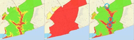
NATIONAL LEVEL DROUGHT RISKS MAP-CURRENT
Drought Risk – Current
Drought Risk – Current
Drought Risk – Future
Figure 10 – Flood Risk – Future
Figure 9 – Flood Risk – Current
EWS Master Plan – Final 06-Aug-2015

A report of the implementation of a Climate-induced Disaster Management Project in all ten (10) regions of Ghana by a consortium of Royal HaskoningDHV and the WASH Sector of SNV […]
Central Training Report As per the Training Programme that was agreed with the CREW Team, the training that was conducted consisted of 2 main elements: central training (in Accra, for […]
The CREW project is one of the efforts being deployed to follow up on the conclusions of The African Adaptation Programme (AAP) in Ghana by extending the risk mapping to […]
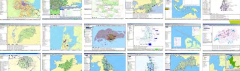
Technical Note – Risk mapping assessment report Draft Links to the Draft national level maps: – hazard maps: https://royalhaskoningdhv.box.com/s/wrufht5jxifhj80pvco1. – vulnerability maps: https://royalhaskoningdhv.box.com/s/66kct8ns2q71mwwjojwk. – risk maps: https://royalhaskoningdhv.box.com/s/onvt8ee3unyobyn6rlzl
We are hosting the Second CREW Technical Research Working Group meeting from 23rd t0 24th July 2014 The team shall review progress of work and finalize the methodology and questionnaire […]
